Pandas: Difference between revisions
Brian Wilson (talk | contribs) |
Brian Wilson (talk | contribs) |
||
| (One intermediate revision by the same user not shown) | |||
| Line 266: | Line 266: | ||
[5 rows x 25 columns] | [5 rows x 25 columns] | ||
Amazed I am. | Amazed I am. "roads.plot()" will run but since I am on a terminal window it had no place to open the plot. I'd need X11 working | ||
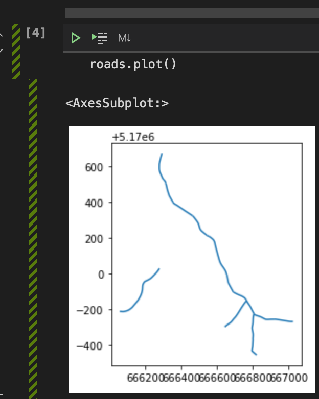
but I think I'll try VSCODE in remote mode first. And it too, works! Thrilled I am. | |||
[[File:roads_on_bellman.png]] | |||
== References == | == References == | ||
Latest revision as of 05:58, 27 March 2021
All this stuff is amazing but hard to wrap my head around because it's more like working with SQL than nice linear procedural programming.
When something is hard for me, I write about it in my Wiki.
This page currently is really all about GeoPandas, for now.
There is also the ArcGIS version and I should write about that here too.
Pandas
This is a Python package for manipulating data that implements dataframes. Dataframes are well amazing. Also extremely well documented elsewhere.
So run along and learn Pandas THEN come back and learn GeoPandas.
Esri "ArcGIS API for Python"
Yeah so you can go install this and learn about it, docs are... difficult.
They have these installed,
packages in environment at C:\Program Files\ArcGIS\Pro\bin\Python\envs\arcgispro-py3: # # Name Version Build Channel appdirs 1.4.4 py_0 arcgis 1.8.3 py37_1668 esri arcgispro 2.7 0 esri arcpy 2.7 py37_arcgispro_26810 [arcgispro] esri argon2-cffi 20.1.0 py37he774522_1 asn1crypto 1.4.0 py_0 async_generator 1.10 py_0 atomicwrites 1.4.0 py_0 attrs 20.2.0 py_0 backcall 0.2.0 py_0 black 19.10b0 py_0 blas 1.0 mkl bleach 3.2.1 py_0 blinker 1.4 py37_0 brotlipy 0.7.0 py37he774522_1000 cached-property 1.5.2 py_0 certifi 2020.6.20 py37_0 cffi 1.14.3 py37h7a1dbc1_0 cftime 1.0.0b1 py37_0 esri chardet 3.0.4 py37_1003 click 7.1.2 py_0 colorama 0.4.3 py_0 cppzmq 4.4.1 2 esri cryptography 2.8 py37_0 esri cycler 0.10.0 py37_0 decorator 4.4.2 py_0 defusedxml 0.6.0 py_0 despatch 0.1.0 py37_0 esri entrypoints 0.3 py37_0 et_xmlfile 1.0.1 py_1001 fastcache 1.1.0 py37he774522_0 flake8 3.8.3 py_0 freetype 2.10.1 vc14_0 [vc14] esri future 0.18.2 py37_0 esri gdal 2.3.3 arcgispro_py37_16713 [arcgispro] esri h5py 2.10.0 py37_arcgispro_9 [arcgispro] esri html5lib 1.1 py_0 icc_rt 2019.0.5 arcgispro_0 [arcgispro] esri idna 2.10 py_0 importlib-metadata 1.7.0 py37_0 importlib_metadata 1.7.0 0 iniconfig 1.0.1 py_0 intel-openmp 2020.0 arcgispro_166 [arcgispro] esri ipykernel 5.3.4 py37h5ca1d4c_0 ipython 7.18.1 py37_0 esri ipython_genutils 0.2.0 py37_0 ipywidgets 7.5.1 py_1 jdcal 1.4.1 py_0 jedi 0.17.2 py37_0 esri jinja2 2.11.2 py_0 jpeg 9d 0 esri json5 0.9.4 py37_0 esri jsonschema 3.2.0 py37_1 jupyter_client 6.1.7 py_0 esri jupyter_console 6.2.0 py_2 esri jupyter_contrib_core 0.3.3 py37_3 esri jupyter_contrib_nbextensions 0.5.1 py37_10 esri jupyter_core 4.6.3 py37_2 esri jupyter_highlight_selected_word 0.2.0 py37_2 esri jupyter_latex_envs 1.4.4 py37_1 esri jupyter_nbextensions_configurator 0.4.1 py37_1 esri jupyterlab 2.2.7 py_0 esri jupyterlab_pygments 0.1.1 py_1 esri jupyterlab_server 1.2.0 py_0 keyring 21.4.0 py37_0 esri kiwisolver 1.2.0 py37h74a9793_0 lerc 2.2 py_0 esri libpng 1.6.37 h2a8f88b_0 libsodium 1.0.18 1 esri libtiff 4.1.0 0 esri libxml2 2.9.10 arcgispro_0 [arcgispro] esri libxslt 1.1.34 he774522_0 lxml 4.5.2 py37h1350720_0 lz4-c 1.9.2 hf4a77e7_3 markupsafe 1.1.1 py37hfa6e2cd_1 matplotlib 3.3.1 py37_arcgispro_0 [arcgispro] esri mccabe 0.6.1 py37_1 mistune 0.8.4 py37hfa6e2cd_1001 mkl 2020.0 arcgispro_167 [arcgispro] esri mkl-service 2.3.0 py37hb782905_0 mkl_fft 1.2.0 py37h45dec08_0 mkl_random 1.2.0 py37_0 esri mpmath 1.1.0 py37_0 mypy_extensions 0.4.3 py37_0 nbclient 0.5.0 py_0 esri nbconvert 5.6.1 py37_0 esri nbformat 5.0.7 py_1 esri nest-asyncio 1.3.2 py_0 esri netcdf4 1.5.4 py37_arcgispro_5 [arcgispro] esri networkx 2.5 py37_0 esri nlohmann_json 3.7.0 1 esri nose 1.3.7 py37_1004 notebook 5.7.10 py37_0 ntlm-auth 1.4.0 py_0 esri numexpr 2.7.1 py37h25d0782_0 numpy 1.19.1 py37h5510c5b_0 numpy-base 1.19.1 py37ha3acd2a_0 oauthlib 3.1.0 py_0 olefile 0.46 py37_0 openpyxl 3.0.5 py_0 openssl 1.1.1g 2 esri packaging 20.4 py_0 pandas 1.1.1 py37ha925a31_0 pandocfilters 1.4.2 py37_1 parso 0.7.0 py_0 pathspec 0.7.0 py_0 pefile 2019.4.18 py_0 pickleshare 0.7.5 py37_1001 pillow-simd 7.1.2 py37_3 esri pip 20.2.2 py37_0 pluggy 0.13.1 py37_0 pro_notebook_integration 2.7 py37_1 esri prometheus_client 0.8.0 py_0 esri prompt_toolkit 3.0.5 py_0 esri psutil 5.7.2 py37he774522_0 py 1.9.0 py_0 pybind11 2.3.0 1 esri pycodestyle 2.6.0 py_0 pycparser 2.20 py_2 pyflakes 2.2.0 py_0 pygments 2.7.0 py_0 esri pyjwt 1.7.1 py37_0 pyopenssl 19.1.0 py_1 pyparsing 2.4.7 py_0 pypdf2 1.26.0 py_2 esri pyrsistent 0.17.3 py37he774522_0 pyshp 2.1.2 py_0 pysocks 1.7.1 py37_1 pytest 6.1.1 py37_0 esri python 3.7.9 2 esri python-certifi-win32 1.2 py37_0 esri python-dateutil 2.8.1 py_0 pytz 2020.1 py37_0 esri pywin32-ctypes 0.2.0 pypi_0 pypi pywin32-security 228 py37_3 esri pywinpty 0.5.7 py37_0 esri pyyaml 5.3.1 py37he774522_1 pyzmq 19.0.2 py37_1 esri regex 2020.7.14 py37he774522_0 requests 2.24.0 py_0 requests-kerberos 0.12.0 0 esri requests-negotiate-sspi 0.5.2 py37_1 esri requests-oauthlib 1.3.0 py_0 requests-toolbelt 0.9.1 py_0 requests_ntlm 1.1.0 py_0 esri scipy 1.5.2 py37h9439919_0 send2trash 1.5.0 py37_0 setuptools 49.6.0 py37_0 simplegeneric 0.8.1 py37_2 six 1.15.0 py_0 sqlite 3.33.0 h2a8f88b_0 sympy 1.5.1 py37_0 esri terminado 0.8.3 py37_0 testpath 0.4.4 py_0 toml 0.10.1 py_0 tornado 6.0.4 py37he774522_1 traitlets 4.3.3 py37_0 typed-ast 1.4.1 py37he774522_0 typing_extensions 3.7.4.3 py_0 ujson 3.1.0 py37ha925a31_0 urllib3 1.25.10 py_0 vc 14.1 h0510ff6_4 vs2015_runtime 14.16.27012 hf0eaf9b_0 esri wcwidth 0.2.5 py_0 webencodings 0.5.1 py37_1 wheel 0.35.1 py_0 widgetsnbextension 3.5.1 py37_0 win_inet_pton 1.1.0 py37_0 wincertstore 0.2 py37_0 winkerberos 0.7.0 py37_1 winpty 0.4.3 4 wrapt 1.12.1 py37he774522_1 x86cpu 0.4 py37_1 esri xarray 0.16.0 py_0 xeus 0.24.1 1 esri xlrd 1.2.0 py_0 xlwt 1.3.0 py37_0 xtl 0.6.5 1 esri xz 5.2.5 h62dcd97_0 yaml 0.2.5 0 esri zeromq 4.3.2 2 esri zipp 3.1.0 py_0 zlib 1.2.11 h62dcd97_4 zstd 1.4.5 h04227a9_0
GeoPandas
GeoPandas is geospatially enabled Pandas. Go right to the page for full info, https://geopandas.org.
Installation
Apparently there is a problem using the geopandas package and its dependencies from conda-forge. Long form, problem with fiona: https://github.com/geopandas/geopandas/issues/989 Short answer: disable conda-forge in .condarc and start again.
conda remote -n geopandas --all
conda create -n geopandas python autopep8 geopandas matplotlib jupyter jupyterlab
conda activate geopandas
In "conda list" I see conda found packages in the esri channel, not sure where exactly it picked that up. So be it. I ran the same commands on my tiny Linux server, Bellman, and it happily complied. I note it did not grab anything from esri, I must have had something cached at work?
Hello World from GeoPandas
In VSCODE, start a Jupyter Notebook. Follow along with someone else's sample. See the Reference section below.
import pandas as pd
import geopandas
import matplotlib as plt
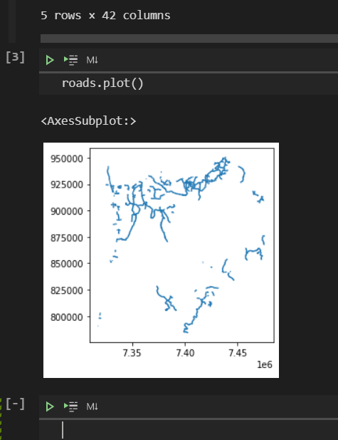
roads = geopandas.read_file("K:/LISData/roads_county.shp") # Of course put your own shapefile here!
roads.head(5)
and I glory in this!
STREET	FROMLEFT	TOLEFT	FROMRIGHT	TORIGHT	LESN	RESN	NOTES	COMMENTS	ST_CHK	...	SYMBOL	CITY	IRISNUM	sign_lomil	sign_himil	FUNCLASSD	FUNCLASSM	FUNCLASSN	Shape_Leng	geometry
0	HIGHLANDS LN	33301	33399	33300	33398	None	None	None	VERIFY ADDRESS RANGE	GSI	...	18	None	1010.0	0.15	0.29	Rural Local	Local	4	960.080746	LINESTRING (7333565.484 887114.321, 7333598.68...
1	HAWKINS RD	90200	90298	90201	90299	None	None	None	None	GSI	...	18	None	1020.0	0.19	0.51	Rural Local	Local	4	1038.814776	LINESTRING (7336949.000 902144.750, 7336920.40...
2	MAKI RD	0	0	0	0	None	None	None	None	None	...	18	None	411.0	0.00	0.93	Rural Local	Local	4	325.748159	LINESTRING (7399846.775 921085.451, 7399836.70...
3	LOWER NEHALEM RD	79500	79998	79501	79999	None	None	None	None	GSI	...	19	None	1404.0	3.21	5.25	Rural Major Collector	Collector	3	6089.149044	LINESTRING (7411398.616 799370.758, 7411406.96...
4	LOWER NEHALEM RD
and CRIKEY it works, right there in VSCODE, the wonder of it!
On the Linux box Bellman, I started ipython3 from the command line and pasted the code in. Over there, I had to use the shape file /home/bwilson/source/GIS/libspatialite-4.3.0/test/shp/merano-3d/roads.shp and instantaneously it responded with
   PK_UID  FEATURE_ID  CODE  SUB_TYPE  ...     E_ID  WINKEL    Length                                           geometry
0     156       92002     0        20  ...  9200200       0  0.192562  LINESTRING (666766.765 5169845.031, 666762.979...
1     185       92002     0        20  ...  9200200       0  0.011543  LINESTRING (666544.351 5170211.610, 666554.939...
2     187       92002     0        20  ...  9200200       0  0.138272  LINESTRING (666544.351 5170211.610, 666544.345...
3     188       92002     0        20  ...  9200200       0  0.115159  LINESTRING (666354.540 5170396.642, 666350.671...
4     189       92002     0        20  ...  9200200       0  0.134453  LINESTRING (666354.540 5170396.642, 666354.545...
[5 rows x 25 columns]
Amazed I am. "roads.plot()" will run but since I am on a terminal window it had no place to open the plot. I'd need X11 working but I think I'll try VSCODE in remote mode first. And it too, works! Thrilled I am.
References
Mastering pandas - Second Edition has a short but sweet chapter on GeoPandas.
Learning Geospatial Analysis with Python - Third Edition has just a brief description of GeoPandas
There are some older references in O'Reilly as well.
This video with Andy Eschbacher has some talk about GeoPandas starting at about 30:00 More tools to look at (ugh): matplotlib, Folium

