MrSID files
MrSID is a proprietary compressed image file format of [LizardTech] It has become very popular for GIS files, especially orthophotos because it is efficient and (can be) lossless.
LizardTech provides a free decoder. It is available for Windows, Linux and Solaris. It will convert MrSID images to JPG, GeoTIFF image formats. It can also scale images, extract part of an image, and a few other things. This makes it possible to use MrSID images in programs that do not support directly reading it.
Lately I have been using GDAL a fair bit, and LizardTech also supplies a decoder that can be incorporated into GDAL at build time, so that you can read MrSID rasters with the GDAL tools. I have tested it on Linux. Works great.
Testing LizardTech tools
This is a temporary page placed here to convey the results of a test to tech support at LizardTech.
Reprojection with datum shift
Input: Corvallis air photo in SID format
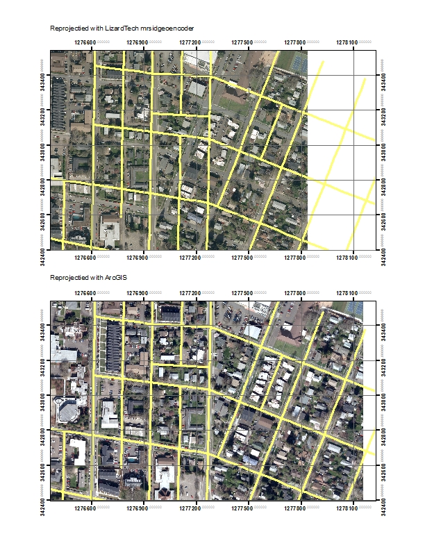
Output: reprojected using mrsidgeoencoder (21 MB) (Command runs but image is shifted.)
Output: using ArcGIS 9.3.1 (300 MB) Raster Reproject (Works correctly.)
Note, ArcGIS output is in IMG format because ArcGIS cannot write SID.
MrSID command and output:
/usr/local/LizardTech/GeoExpress8/bin/mrsidgeoencoder \
-of mg3 -lossless -towkt NAD_1927_StatePlane_Oregon_North_FIPS_3601.prj \
-i 11s5w34f_color_ne.sid -o  11s5w34f_color_ne_nad27.sid
Using local license
Input file name: 11s5w34f_color_ne.sid
Output file name: 11s5w34f_color_ne_nad27.sid
Output format: MrSID Generation 3
Estimated memory required: 33.7 MB
Encoder version: 8.0.0.3065.Bob_3062_br
Encode start time: Mon Apr 11 15:53:06 2011
Encode finish time: Mon Apr 11 15:55:46 2011
Total encode time: 2 minutes, 40 seconds
Input image size: 314.7 MB (329941728 bytes)
Output file size: 21.1 MB (22090787 bytes)
Encode ratio: 14.94:1 (lossless)
Data Cartridge not decremented
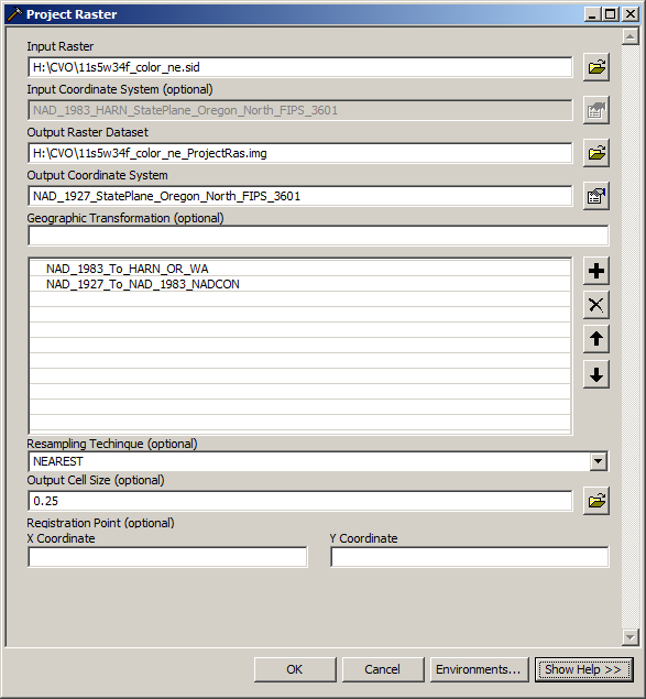
ArcGIS command:
I used the same WKT projection file to do both reprojections. Here is a copy of that file. NAD_1927_StatePlane_Oregon_North_FIPS_3601.prj
Screenshot of results
Note that in the top image, the streets do not align with the reprojected image. It appears that the image is still in NAD1983 projection.

