Georeferencing
2015-Sep-03
A case study in georeferencing with ArcGIS 10.3.1
ESRI's documentation is here.
I did georeferencing with old black and white aerial photos a long time ago. Around 2004, so ArcGIS 8.2.
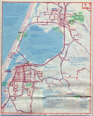
I am trying it with a paper map today, just for kicks. It's a Northern California bicycle map, and it looks almost hand drawn, so I am curious how it will align. I am scanning the Eureka/Arcata area.
Sample image
Scanner settings: full color, 600 DPI. TIFF format.
Here is a scaled down version of the scan for your edification.

The process
- Scan the map.
- Grab some data to which to tie the scan. Just need roads; also grabbed coastal zones. http://www.humboldtgov.org/276/GIS-Data-Download
- Start ArcMap and create a map with roads and coastal zones.
- Add the unreferenced photo as a layer. Ignore the complaints about it being unreferenced. :-)
- Open the georeferencing toolbar. The photo should already show in there.
- Zoom to the approximate area of the map. (It helps to have it open in a TIFF viewer.)
- In the toolbar, select "Fit to display".
- Pick some nice solid control points, like major highway intersections.
- Using the tools create links from the scan to the vector data.
- I chose "Update Georeferencing" to save the references with the TIFF instead of Rectify which would generate a new image. This also means it will probably only work correctly in ArcMap, and maybe QGIS.
Note that Humboldt county is still on NAD27. NAD_1927_StatePlane_California_I_FIPS_0401
After doing the georeferencing I think the cartographer pulled the data from the same projection; it only required 3 points to pull it into alignment.